About
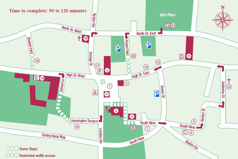
A guided walk through Uppingham’s Heritage. There are 20 identified sites numbered on the map. You will see 7 information boards, A to G, along the route together with QR codes which are links to the website, where you will find even more information.
Download the Uppingham Heritage Trail PDF here.
1 Market Place. This is the social and commercial centre of the town. Originally it was larger, but the western side of the Market Place was demolished in the 1960s for road widening. Although a Market Charter was granted in 1281, there was a market on this site many years before that. The drinking fountain commemorates Queen Victoria’s Golden Jubilee of 1887 and was designed by Charles Rossiter, the art master at Uppingham School.
2 Falcon Hotel. The large, modern, neo-Gothic front (1870) dominates the Market Place, hiding a 16th-century building behind. The Falcon was once a coaching inn. The central archway, allowing access for coaches, and courtyard behind are now enclosed.
3 Norton’s Plough. Norton’s is the latest in a series of family-run ironmongers trading on this site since 1761. The plough above the door has been there since the mid-19th century.
4 Post Office. The Post Office moved here in 1896 from the High Street. This 18th century building was formerly a doctor’s surgery.
5 Parish Church. Dedicated to St Peter and St Paul, this largely 14th century building was extensively restored and enlarged in 1861. There are some fine 12th-century carved figures either side of the north door. Further information on the church is available inside.
6 Old Grammar School. This school, together with one at Oakham, was built in 1584 by Archdeacon Robert Johnson. From this small country schoolroom a great public school developed in the 19th century, attracting pupils from all over the country. (The town’s pinfold is over the wall on your right as you walk to site 7.)
7 Beast Hill. It was here that cattle were herded on market days, hence the name Beast Hill.
8 Railway Station. This site is known as Hog Hill and was the site of a pig market. Station Road at the bottom led to the old L.N.W.R. station, now demolished. The train came to Uppingham in 1894; passenger train services ceased in 1960 and the station closed in 1964.
9 Fossil Wall. There are some fossils in the old stone wall leading round to Norton Street. The bastion in the wall is made from locally sourced limestone of the same type used to build Peterborough Cathedral.
10 Congregational Chapel. This chapel, converted into accommodation in 2005, was built in 1814, replacing an earlier building of 1770. On your way to it you will pass the old tower brewery which is now a private home.
11 Town Hall. This is a modern building which was formerly the church rooms in the early 20th century.
12 High Street East. Throughout the years this has been Uppingham’s main shopping street, meeting the daily needs of the townspeople. In many cases the main structure of the buildings is considerably older than the façade.
13 Uppingham Public Houses. In the 18th century Uppingham had almost 30 public houses. Now only six public licensed premises remain.
14 Uppingham School. Visible from School Lane is Archdeacon Johnson’s Hospital (an almshouse for 24 old men) built in 1592, and the Schoolmaster’s House. The building with the image over the door is the location of the original chapel. By 1730 this building ceased to be a Hospital and became a boarding house for boys (School House). When School House moved to its present location in 1890 this 16th century building was converted into the school Library. The school and its grounds are private property and must be viewed from the public highway.
15 Sheilds Yard. On the north side of High Street West, between numbers 36 and 38, you will find a low stone archway leading into Sheilds Yard. This is typical of the many yards in Uppingham. Note the lead-headed pump dated 1805. The name and spelling derives from a family who lived here.
16 Leamington Terrace. This lane was once the site of the town wash pond for horses until it was gentrified in the 19th century! Generations of schoolboys walked this route between the schoolroom in the churchyard and the main school buildings through the archway at the top of the terrace.
17 Orange Street. This was probably named after a 15th century attorney, Thomas Orange. Another possibility is that the name comes from the annual Orange Fair. Bear Yard on the right-hand side of the street indicates the approximate site of a former barn where travelling circus animals were kept.
18 Methodist Church. Methodists have worshipped in Uppingham since the early 19th century. This 1872 building replaced one dating back to 1819. It was extended in 1887 and restored in 1999.
19 Tod’s Piece. The Parish Council (now Uppingham Town Council) purchased the land in 1928. There is a legend saying that a man named Tod took a wager that he could completely scythe the field in one day. He won his bet but dropped down dead from his exertions.
20 Hopes Yard. This yard, named after a chemist who had a shop at 15 High Street East, is one of the many jitties and yards leading off the High Street. Although much altered, The Little Crooked House has some 16th-century fabric. Further up the yard an old medieval window has been reset in the side of a building.